No higher resolution available.
Site_of_Rothwell_Castle_-_geograph.org.uk_-_1366733.jpg (640 × 480 pixels, file size: 327 KB, MIME type: image/jpeg)
Summary
| Description |
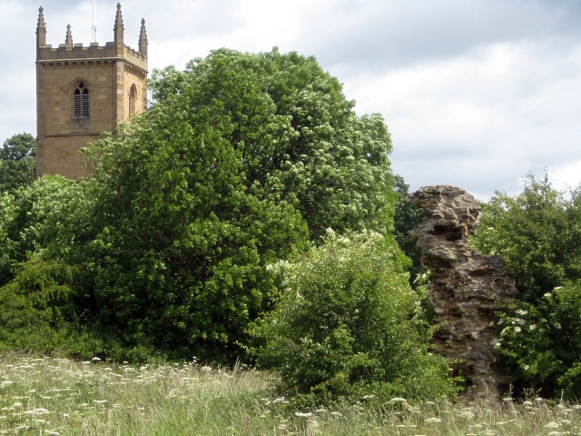
English: Site of Rothwell Castle The site of Rothwell Castle is a Scheduled Ancient Monument, (Monument number 52655). The stump of masonry which appears above ground today may not appear to be much, but in medieval times it was a hunting lodge for the kings of England. King John, Edward II, Edward III and Henry VI are all known to have spent time there.
Rothwell Holy Trinity church features in the background. http://www.lhi.org.uk/docs/YH00827_Rothwell_Leaflet.pdf |
| Date | |
| Source | From geograph.org.uk |
| Author | Mike Kirby |
| Attribution (required by the license) | Mike Kirby / Site of Rothwell Castle / |
| Camera location | | View this and other nearby images on: OpenStreetMap |
|---|
| Object location | | View this and other nearby images on: OpenStreetMap |
|---|
Licensing

|
This image was taken from the Geograph project collection. See this photograph's page on the Geograph website for the photographer's contact details. The copyright on this image is owned by Mike Kirby and is licensed for reuse under the Creative Commons Attribution-ShareAlike 2.0 license.
|
This file is licensed under the Creative Commons Attribution-Share Alike 2.0 Generic license.
Attribution: Mike Kirby
- You are free:
- to share – to copy, distribute and transmit the work
- to remix – to adapt the work
- Under the following conditions:
- attribution – You must give appropriate credit, provide a link to the license, and indicate if changes were made. You may do so in any reasonable manner, but not in any way that suggests the licensor endorses you or your use.
- share alike – If you remix, transform, or build upon the material, you must distribute your contributions under the same or compatible license as the original.
File history
Click on a date/time to view the file as it appeared at that time.
| Date/Time | Thumbnail | Dimensions | User | Comment | |
|---|---|---|---|---|---|
| current | 13:20, 28 February 2011 | | 640 × 480 (327 KB) | wikimediacommons>GeographBot | == {{int:filedesc}} == {{Information |description={{en|1=Site of Rothwell Castle The site of Rothwell Castle is a Scheduled Ancient Monument, (Monument number 52655). The stump of masonry which appears above ground today may not appear to be much, but in |
File usage
The following page uses this file:

_heading:45.00&language=en)
_heading:45.00&language=en)