(Added more of the archaeology report) |
No edit summary |
||
| (35 intermediate revisions by the same user not shown) | |||
| Line 1: | Line 1: | ||
{{Mobile map fix}} |
|||
'''Rothwell Country Park''' (rarely referred to as '''Millennium Park'''<ref name="LHLCP" />) is a 52 hectares public park, between the north of Rothwell and the Aire and Calder Navigation. |
|||
{{Contribute notice}} |
|||
The park is a [https://www.wildlifetrusts.org/local-wildlife-sites Local Wildlife Site]<ref name="wtreport" />, with a pond trail and a sculpture trail; a summit, which offers a view of Leeds; and connections to the Trans-Pennine Way. <ref name) is a 52 hectares public park, between the north of Rothwell and the Aire and Calder Navigation. The park is a text-align:center"> '''A view of one of Rothwell Country Park's ponds in 2010.''' <br/>[https://www.geograph.org.uk/photo/2036080 Photo] © [https://www.geograph.org.uk/profile/760 Mark Anderson] ([https://creativecommons.org/licenses/by-sa/2.0/ cc-by-sa/2.0])</div> |
|||
'''Rothwell Country Park''' is a 52 hectares public park, between the north of Rothwell and the Aire and Calder Navigation. |
|||
| aka = Millennium Park <ref name="LHLCP"> West, with a pond trail and a sculpture trail; a summit, which offers a view of Leeds; and connections to the Trans-Pennine Way.e Characterisation Project Final Report''. [online] Leeds: WYJS, p.750. Available at: <https://www.wyjs.org.uk/media/69833/leeds-historic-landscape-characterisation-project-report. |
|||
The park is a [https://www.wildlifetrusts.org/local-wildlife-sites Local Wildlife Site]<ref name="wtreport"> The Wildlife Trust (2020). "What's the Damage?". [online]. Available at: <https://www.wildlifetrusts.org/sites/default/files/2020-01/What's%20the%20damage%20-%20Full%20Report%20digital2_0.pdf> [Accessed 7/12/2020]</ref>, with a pond trail and a sculpture trail; a summit, which offers a view of Leeds; and connections to the Trans-Pennine Way. <ref name="ywt">Yorkshire Wildlife Trust. "Rothwell Country Park". [online]. Available at: <https://www.ywt.org.uk/nature-reserves/rothwell-country-park> [Accessed 3/12/2020]</ref> |
|||
{{Infobox place |
{{Infobox place |
||
| name = Rothwell Country Park |
| name = Rothwell Country Park |
||
| image = 2036080 1848db8e.jpg |
| image = 2036080 1848db8e.jpg |
||
| alt = An image of a pond at Rothwell Country Park in 2010. |
|||
| caption = <div style="text-align:center"> '''A view of one of Rothwell Country Park's ponds in 2010.''' <br/>[https://www.geograph.org.uk/photo/2036080 Photo] © [https://www.geograph.org.uk/profile/760 Mark Anderson] ([https://creativecommons.org/licenses/by-sa/2.0/ cc-by-sa/2.0])</div> |
|||
| caption = A view of one of Rothwell Country Park's ponds in 2010. |
|||
| aka = Millennium Park |
|||
| attribution = [https://www.geograph.org.uk/photo/2036080 Photo] © [https://www.geograph.org.uk/profile/760 Mark Anderson] ([https://creativecommons.org/licenses/by-sa/2.0/ cc-by-sa/2.0]) |
|||
| aka = * Millennium Park <ref name="LHLCP"> West Yorkshire Joint Services, West Yorkshire Archaeology Advisory Service and Historic England, 2017. ''Leeds Historic Landscape Characterisation Project Final Report''. [online] Leeds: WYJS, p.750. Available at: <https://www.wyjs.org.uk/media/69833/leeds-historic-landscape-characterisation-project-report.pdf> [Accessed 17 July 2022].</ref> |
|||
* Rothwell Colliery Country Park <ref> leeds.gov.uk. n.d. ''Forest of Leeds - Rothwell''. [online] Available at: <http://web.archive.org/web/20120220102139/http://www.leeds.gov.uk/fol/fol_46.html> [Accessed 20 July 2022].</ref> |
|||
| category = Park |
| category = Park |
||
| times = Open at all times |
| times = Open at all times |
||
| Line 17: | Line 20: | ||
| purpose = |
| purpose = |
||
| link = |
| link = |
||
| |
| location = Rothwell Country Park |
||
| street = Bullough Lane |
| street = Bullough Lane |
||
| postcode = LS26 0JY |
| postcode = LS26 0JY |
||
| nearby = |
| nearby = |
||
}} |
}} |
||
The park opened on the 24th of June 2000<ref name="frcp" /> and is managed by Leeds City Council, in partnership with the Yorkshire Wildlife Trust and the Friends of Rothwell Country Park.<ref name="ywt" /> |
The park opened on the 24th of June 2000<ref name="frcp" /> and is managed by Leeds City Council, in partnership with the Yorkshire Wildlife Trust and the Friends of Rothwell Country Park.<ref name="ywt" /> The park has approximately 676,817 vistors annually, which makes it the second most visited park in the Leeds South Outer management area, after Springhead Park. Rothwell Country Park is the sole park among Leeds' top 25 most visited parks that does not meet the Leeds Quality Park standard.<ref name="park survey">Barker, A., Churchill, D. and Crawford, A. (2018) Leeds Parks Survey: Full Report. rep. Leeds: University of Leeds.</ref> |
||
The site was excavated in the 1970s and was found to have been possibly inhabited in the Roman era.<ref name="Richardson" /> It was also a hunting ground in the Medieval period and then a colliery in the 19th and 20th Centuries, until it was redeveloped in the mid 1990s.<ref name="frcp">Friends of Rothwell Country Park. "History of the Park". [online]. Available at:<https://sites.google.com/site/friendsofrothwellcountrypark/about-the-park> [Accessed 3/12/2020]</ref> |
The site was excavated in the 1970s and was found to have been possibly inhabited in the Roman era.<ref name="Richardson">Richardson, J., 2011. ''Rothwell Haigh, Rothwell, Leeds, West Yorkshire - Excavation Report''. [online] Wakefield: ASWYAS. Available at: https://archaeologydataservice.ac.uk/archiveDS/archiveDownload?t=arch-941-1/dissemination/pdf/archaeol11-92831_1.pdf [Accessed 17 July 2022].</ref> It was also a hunting ground in the Medieval period and then a colliery in the 19th and 20th Centuries, until it was redeveloped in the mid 1990s.<ref name="frcp">Friends of Rothwell Country Park. "History of the Park". [online]. Available at:<https://sites.google.com/site/friendsofrothwellcountrypark/about-the-park> [Accessed 3/12/2020]</ref> |
||
[[Category:Mining History]] |
[[Category:Mining History]] |
||
=History of the Site= |
==History of the Site== |
||
==Roman Britain== |
===Roman Britain=== |
||
''Main Article: [[Possible Roman Settlement (Rothwell Haigh)]]''<br> |
|||
===Excavation at Rothwell Country Park=== |
|||
In |
In the 1970s, the West the West Yorkshire County Archaeology Unit excavated a "ditched rectangular enclosure" at Rothwell Colliery (approx. grid reference SE 352 295 or SE 352 297<ref group="footnotes">[https://www.heritagegateway.org.uk/Gateway/Results_Single.aspx?uid=cf53bdd6-3f9c-4c31-8533-5d8708c9829c&resourceID=19191 Heritage Gateway] also lists the grid reference SE3521029410, which is more exact than that given by Richardson.</ref>) , which is now the site of Rothwell Country Park. |
||
<div align="center"> |
<div align="center"> |
||
{{#display_map:53°45'46"N, 1°28'0"W; 53°45'40"N, |
{{#display_map:53°45'46"N, 1°28'0"W; 53°45'40"N, |
||
1°28'0"W|width= 300px|height=150|zoom=15|margin: 0 auto; |
1°28'0"W|scrollwheelzoom= off|width= 300px|height=150|zoom=15|margin: 0 auto; |
||
}}''The approximate locations of the excavation site.'' |
}}''The approximate locations of the excavation site.'' |
||
==== Roman-era well==== |
|||
The most significant finding from the excavation was that of a Roman-era well. The well was 12.3-12.6m deep and approximately 2m wide. Like the well found in [https://en.wikipedia.org/wiki/Dalton_Parlours_Roman_villa Dalton Parlours villa] in Wetherby, it had been cut through bedrock. However, due to the lack of evidence for the contemporary ground surface level, the team were unable to determine the true height of the well as some of it may have been destroyed before the excavation. The archaeology unit emptied the well in its entirety and found that it was "damp to c. 5.5m, wet from 5.5m to just over 7m and thereafter, waterlogged." Throughout the well there were building debris, from a few structural stones to ceramic and stone tiles.<ref name="Richardson" /> |
|||
====Pottery==== |
|||
The pottery found consisted mainly of pieces that would have been used to prepare and eat food. The pottery indicated that the well was in-use as early as the late 2nd century or early 3rd century, with "subsequent infilling indicates a date in the late 3rd century at the earliest, with rapid infilling in the early to mid-4th century". <ref name="Richardson" /> |
|||
====Samian ware==== |
|||
[[File:Roman samian ware sherds. (FindID 73523).jpg|alt=Roman samian ware|left|thumb|200x200px|An example of Roman samian ware - not those found on site.]] |
|||
There were eleven [https://en.wikipedia.org/wiki/Terra_sigillata samian sherds] found at the excavation site, nine of which were found within the well. One sherd was dated to AD 120-160, while the rest was dated to the second half of the 2nd century and the 3rd century. Slightly less than half of the sherd were [https://en.wikipedia.org/wiki/Terra_sigillata#East_Gaulish_samian_ware East Gaulish fabrics], while the rest was [https://en.wikipedia.org/wiki/Terra_sigillata#Central_Gaulish_samian_ware Central Gaulish vessels]. By the time the well was being filled in (late 3rd - early 4th century), samian ware was no longer being imported into Britain.<ref name="Richardson" /> |
|||
====Metalwork==== |
|||
There was only a small amount of metalwork found in the well, most of which was generally fragmentary iron nails. |
|||
There was however, an item which puzzled the archaeologists as it "does not resemble any of the normal metals in use during the Roman period" and was initially though to be a bone. The item was found in the bottom waterlogged part of the well, where it had been eroded so much that there were holes through it. The expert on the metalwork ruled out iron and lead alloy, but could not be certain that it was not a copper alloy or silver. It is possible the item was part of a finger ring, a type which was made from the 3rd - 5th centuries. |
|||
There was no evidence to suggest that the items were part of any rites (such as burial rites), however iron nails have been found to be used in this context.<ref name="Richardson" /> |
|||
====Ceramic building material==== |
|||
[[File:Feurs Musée Tegulae Imbrices.JPG|alt=Teguale and Imbrices|thumb|150x150px|An example of tegulae and imbrices - not those found on site.]] |
|||
[[File:Roman box flue tile (FindID 492495).jpg|alt=Roman box flue tile|thumb|An example of a Roman box flue tile - not those found on site.|150x150px]] |
|||
There were 32 fragments of ceramic building materials found in the excavation of the well, with a combined weight of 4253g and a "colour range between Weak Red (10R5/4) to Reddish Yellow (7.5YR/6/6)". There were two forms identified: "roof tile ([https://en.wikipedia.org/wiki/Imbrex_and_tegula tegulae and imbrices/ridge]) and [https://en.wikipedia.org/wiki/Ancient_Roman_pottery#Brick,_tile_and_other_architectural_ceramics boxflue tile]". |
|||
69% of the total fragments were tegulae, which were estimated to be eight individual tiles. Some of these fragments contained clues to the means of suspension; eight had flanges, two had nail/peg holes and three had cut-aways. Some of the tiles also had paw print impressions from a small dog, which is not unusual on ancient bricks and tiles. |
|||
19% of the total fragments were imbrices, which were estimated to be three individual tiles. There was uncertainty whether these were truly distinct from the tegulae. |
|||
6% of the fragments were box-flue tiles. |
|||
It is possible that the majority of the material was dumped in a single episode as most were found between 10-12m in the well. There are sparse fragments of the material at other levels, "suggests that dumping during the later phases was of a domestic nature". <ref name="Richardson" /> |
|||
====Stone roof tiles ==== |
|||
There were nine fragments of [https://www.c82.net/mineralogy/b539 Micaceous Sandstone] roof tiles, one of which is complete and another of which is near complete. "Three different shapes of tile were provisionally identified: diamond, sub-rectangular and pentagonal, the latter examples displaying curved sides leading to a flat base."<ref name="Richardson" /> |
|||
====Querns and other stone artefacts==== |
|||
[[File:Quernupper.jpg|left|thumb|150x150px|An example of the upper part of a quern stone - not those found on site.|alt=Upper part of quern stone]] |
|||
[[File:Cliffecastlemus 016.jpg|left|thumb|An example of a beehive quern - not those found on site.|alt=Beehive quern|150x150px]] |
|||
A group of Late Iron Age and Romano-British querns were found mostly in the well and a large pit. Most of the [https://en.wikipedia.org/wiki/Quern-stone#/media/File:Quernupper.jpg querns] are of the flat form and at least two are "probably millstones rather than hand querns". They are typical of those found from these eras in West Yorkshire. |
|||
There are two well made beehive querns (usually dated BC 200 - AD 200, but there are known to be later examples) made from [https://en.wikipedia.org/wiki/Pennine_Coal_Measures_Group Coal Measures] sandstone. |
|||
"The flat querns are a mixture of local lithological types and [https://en.wikipedia.org/wiki/Millstone_Grit Millstone Grits]. Four of the six disc forms could well come from millstones rather than hand-turned querns, a high percentage for rural sites". |
|||
The most unusual quern found at the site was that of the disk rough-out, which would usually only be found at production sites. At the time of the archaeology report, there was only one rough-out found within 50km of Rothwell. Its presence hints at form of [https://www.oxfordreference.com/view/10.1093/oi/authority.20110803100538144 structured deposition], as rough-outs were used in the Iron Age for [https://hutchiearchaeology.blogspot.com/2013/01/votive-offerings.html votive deposition].<ref name="Richardson" /> |
|||
====Structural stone work==== |
|||
Most of the stones found were unworked pieces, those some show evidence of heat-redding, while some may have been collected for their appearance. There was one stone with a clear structural use, another that was also worked, and a stone possibly modified.<ref name="Richardson" /> |
|||
====Wooden artefacts==== |
|||
All the surviving wooden artefacts are in the bottom waterlogged part of the well as they would not have survived in the non-waterlogged layers, even if they were present. All of the wood species identified were native. |
|||
A wooden bucket was found, but, due to it the specialist craft needed to produce it, it was likely made elsewhere. "This artefact and the iron-fitted spade, indicate links with other communities with access to specialist skills and equipment." It was unusual in that it was made from yew, of which, at the time of the report, only one Romano-British bucket fragment was made from yew. |
|||
[https://en.wikipedia.org/wiki/Stave_(wood) Staves] were found with nail holes that suggest they were once part of a structure or larger artefact. The offcuts and chippings found, which likely were produced in the breaking up of larger pieces of wood or timber structures, also support this idea. Wooden pegs, associated with framed wooden structures, were found. |
|||
A bracket was found, of which the function could not be determined, but which could have been used to secure timber or metal bars, or part of a drawbar mechanism for a large door or gate, or even a lifting mechanism to draw water from the well. |
|||
Three turned vessels, with simple but carefully finished decoration, were found, which were likely used as drinking vessels. They were likely broken before they were deposited in the well. It is unclear whether they were viewed as waste or "a token deliberately thrown into the well". |
|||
Other items found included a spade and a bucket handle. |
|||
The wooden artefacts found were somewhat different from those found at Dalton Parlours, which may indicate that the Rothwell well had "a different, perhaps less long-lived, working life to the well or that very different activities were taking place above ground".<ref name="ywt" /> |
|||
==== Leather and footwear ==== |
|||
A number of leather artefacts were found in the waterlogged section of the well, up to 8.8m. Any leather higher than this would have perished due to the non-waterlogged conditions. The leather artefacts are mainly "footwear, with some off cuts, a strip with pricked decoration, and a curious oval object". The finds are similar to that found at Dalton Parlours. |
|||
A nailed bottom shoe is the best persevered piece of footwear. It is 21cm in length (a child size 13 or adult size 1). It lacks the upper part of the shoe, but the strips of goatskin used to reinforce the lasting margins are well preserved. There is evidence that the shoe was modified after it was made to alleviate pressure on the bottom edge of the foot. The leather shoes signs of wear from use. |
|||
Another shoe found seems to "have been specially made to cope with some sort of temporary affliction". These modifications are well know in post-medieval footwear but not in Roman footwear. |
|||
Some of the shoes had a distinct pattern, not previously seen elsewhere. Although they generally followed similar trends from artefacts found in Britain and the Continent. |
|||
The shoes found in Rothwell and Dalton Parlours are more decorative than similar pieces found elsewhere, "with cusping, openwork and surface impressions, Rothwell even more so than Dalton Parlours." |
|||
There are too few offcuts to suggest that there was a professional leatherworker on the site, however there was some leather working carried out there. The high quality tanned hides were likely to have been purchased elsewhere. Additionally, the "use of thin leather thong rather than twine for stitching is typical for the later Roman periods". The other shoes are likely that of an adult female, with some possibly having been for the same woman with an affliction or discomfort on "the lower heel edge of her left foot". The shoes were dated to the end of the 3rd century to the early 4th century.<ref name="Richardson" /> |
|||
==== Cotton fabric ==== |
|||
There was cotton textile in the well, although it was doubted by the expert who examined it that it was Roman. Cotton is very rare in the western Roman provinces. <ref name="Richardson" /> |
|||
====Human skull==== |
|||
A human skull (possibly from a decapitated person) was found in the well. It likely belonged to a male who was about 25 years old.<ref name="Richardson" /> |
|||
====Animal bones==== |
|||
A total of 4677 fragments of animal bone were found. Below shows a table of the analysed fragments, however due to poor sampling and sieving strategy it may not be a true representation.<ref name="Richardson" /> |
|||
<div style="padding-left: 25%; padding-right: 25%; border: none;"> |
|||
{| class="wikitable" style="width: 300px;" |
|||
|+ |
|||
|- |
|||
!Species |
|||
!Total |
|||
!% |
|||
|- |
|||
|Sheep/Goat |
|||
|489 |
|||
|27 |
|||
|- |
|||
|Dog |
|||
|450 |
|||
|25 |
|||
|- |
|||
|Cattle |
|||
|343 |
|||
|19 |
|||
|- |
|||
|Pig |
|||
|328 |
|||
|18 |
|||
|- |
|||
|Cat |
|||
|44 |
|||
|2 |
|||
|- |
|||
|Chicken/Guinea |
|||
|43 |
|||
|2 |
|||
|- |
|||
|Equid |
|||
|20 |
|||
|1 |
|||
|- |
|||
|Other |
|||
|71 |
|||
|6 |
|||
|} |
|||
</div> |
</div> |
||
The excavation showed that there was evidence of human activity on the site from the late 2nd to the early 3rd century. On the site, a Roman well was found, which had been filled with lots of material, including a rare yew bucket, roman pottery, a human skull.<ref name="Richardson" /> |
|||
The depths (mostly 9.6-10.5m) with the highest concentration of the fragments suggest that there may have been a period of intense dumping. There was evidence of butchery on the sheep/goats whereas, there were limited signs of butchery on the cattle. The sheep found were comparable in height to the smaller Roman sheep found at Dalton Parlours. Additionally, the "cattle are comparable in height to the larger specimens recovered from features dating to the late Romano-British period (AD 350-400) at Greyhound Yard, Dorchester". There was possible sign of tuberculosis on one of the cattle. |
|||
===Middle Ages=== |
|||
The dogs found were a smaller Roman breed, similar to those recovered from [https://en.wikipedia.org/wiki/Tripontium Tripontium]. It was common in from 100-400AD for disused wells to be used for dog burials. At least three types of dog were present. The depositation skeletons may have had symbolic or ritual significance. |
|||
While most species sheep/goats, cattle and dogs had a range of ages, 70% of thee pig specimens had died within their first year. Less than 5% were older than 3.5 years. Only two fragments of teeth were found, one from a male and one from a female. |
|||
A majority of the cats were immature animals, however at least one animal was two years old or older. The immaturity of the cat bones found suggest that they were domesticated animals. |
|||
The equid bones are likely from Roman donkeys, rather than Romano-British horses, due to their size. |
|||
The majority of the bird bones were from chickens, although there were pheasant and guinea fowl bones which are rare in Romano-British sites. There were at minimum four individual chickens. It is likely that whole chickens were deposited in the well. There were other bird bones, including crow, rook, passerine and possibly buzzard. |
|||
There were a number of small mammals including mouse, rat, water vole and frog/toad. They likely fell into the well. |
|||
==== Plant and invertebrate assessment ==== |
|||
==Middle Ages== |
|||
In the Middle Ages, Rothwell Country Park would have been part of a large wooded area that nobility used for hunting, such as wild boars. Nobles such as [[John of Gaunt]] would have hunted regularly in this area. <ref name="frcp" /> |
In the Middle Ages, Rothwell Country Park would have been part of a large wooded area that nobility used for hunting, such as wild boars. Nobles such as [[John of Gaunt]] would have hunted regularly in this area. <ref name="frcp" /> |
||
In 1530, the Royal Hunting Park of Rothwell was de-parked and hunting would have subsided, while cattle grazing and eventually coal mining would have increased. <ref name="frcp" /> |
In 1530, the Royal Hunting Park of Rothwell was de-parked and hunting would have subsided, while cattle grazing and eventually coal mining would have increased. <ref name="frcp" /> |
||
==Fanny Pit== |
===Fanny Pit=== |
||
[[File:Rothwell Colliery - geograph.org.uk - 1565074.jpg|left|thumb|Fanny Pit, as photographed in 1984.]] |
[[File:Rothwell Colliery - geograph.org.uk - 1565074.jpg|left|thumb|Fanny Pit, as photographed in 1984.|alt=An image of mining buildings at Fanny Pit in 1984.]] |
||
Around 1867, the [[Charlesworth Family|Charlesworth family]] sank a shaft on the site, named Fanny Pit, after the daughter of one of the Charlesworths. Despite millions of gallons of water needing to be pumped out of the shaft every week, the shaft was highly profitable. <ref name="frcp" /> |
Around 1867, the [[Charlesworth Family|Charlesworth family]] sank a shaft on the site, named Fanny Pit, after the daughter of one of the Charlesworths. Despite millions of gallons of water needing to be pumped out of the shaft every week, the shaft was highly profitable. <ref name="frcp" /> |
||
| Line 186: | Line 52: | ||
On the 9th December 1983, the last of the Rothwell Colliery's shafts were closed. They had produced over 75 million tons of coal during the time they were open. <ref name="frcp" /> |
On the 9th December 1983, the last of the Rothwell Colliery's shafts were closed. They had produced over 75 million tons of coal during the time they were open. <ref name="frcp" /> |
||
=History of the Park= |
==History of the Park== |
||
In the mid 1990s, local people, Leeds City Council and Groundwork Leeds, entered a partnership to transform the disused industrial site. |
In the mid 1990s, local people, Leeds City Council and Groundwork Leeds, entered a partnership to transform the disused industrial site.<ref name="ywt" /> Construction started in 1997, with the spoil heap lowered, ponds established, trees planted and pathways created.<ref name="LCC report">Barker, K. (2007) Rothwell Country Park. Leeds: Leeds City Council.</ref> Groups and individuals, such as local schoolchildren and local conservationists, contributed to the work. The park was supported by the Millennium Commission, and funding came from the National Lottery's Changing Places programme, Yorkshire Forward, Leeds City Council, the European Commission and the Forestry Commission.<ref name="S Ward Book">Stephen Ward (2020). "Rothwell & District: Pictures & Memories from the Past". Leeds: Stephen Ward Photography and Publishing.</ref> |
||
On the 24th June 2000, Rothwell Country Park was opened <ref name="frcp" /> by television presenter and journalist Richard Whiteley. <ref name="BBC">BBC Leeds (2009). "From Park to Pit". [online]. Available at:<http://www.bbc.co.uk/leeds/content/articles/2009/03/02/places_rothwell_country_park_feature.shtml> [Accessed on 7/12/20]</ref> There was a "traditional village fete", which included music and displays by schools, community groups and societies. There were also tours of the park, some by former miners, who explained the mining history of the park, and others explaining how the park was built and what wildlife now inhabited it. There were displays of crafts including willow weaving and stone carving. <ref name="S Ward Book" /> |
On the 24th June 2000, Rothwell Country Park was opened <ref name="frcp" /> by television presenter and journalist Richard Whiteley. <ref name="BBC">BBC Leeds (2009). "From Park to Pit". [online]. Available at:<http://www.bbc.co.uk/leeds/content/articles/2009/03/02/places_rothwell_country_park_feature.shtml> [Accessed on 7/12/20]</ref> There was a "traditional village fete", which included music and displays by schools, community groups and societies. There were also tours of the park, some by former miners, who explained the mining history of the park, and others explaining how the park was built and what wildlife now inhabited it. There were displays of crafts including willow weaving and stone carving. <ref name="S Ward Book" /> |
||
In 2010, after years of underinvestment <ref name="frcp" /> and vandalism, <ref name="BBC" /> the Friends of Rothwell Country Park was |
Following the park's opening, it experienced a number of issues, including a lack of revenue, the demise of the Friends of group, travellers' encampments, fly tipping and unauthorised vehicles causing damage. There were also plans for the RSPCA to build a visitor or education centre on the site of Haigh Farm, however this did not come to fruition.<ref name="LCC report" /> In 2010, after years of underinvestment <ref name="frcp" /> and vandalism, <ref name="BBC" /> the community group, the Friends of Rothwell Country Park, was reestablished to maintain the park. |
||
On 9th June 2013, the "Trim Trail" was officially opened, which consisted of a series of outdoor exercise equipment. It was funded by Leeds City Council. Members of the Friends of Rothwell Country Park and representatives of Leeds City Council used the equipment session run by Sarah Crosby of Cross-Fit Personal Training.<ref name=":0">Anon (n.d.) “Home,” ''Friends of Rothwell Country Park'', [online] Available from: <nowiki>https://sites.google.com/site/friendsofrothwellcountrypark/home</nowiki> (Accessed 3 February 2023).</ref> |
|||
In 2019, the park was designated a Local Wildlife Site. <ref name="wtreport" /> |
In 2019, the park was designated a Local Wildlife Site. <ref name="wtreport" /> |
||
Rothwell Country Park was one of the 13 Wildlife Trust sites within 500m of the proposed HS2 train line. The Wildlife Trust's 2020 report, "What's the Damage?", highlighted how the new proposed HS2 line would go further south into the site, where the highest level of biodiversity is, and that construction would have caused damage and possibly introduced invasive species that had been |
Rothwell Country Park was one of the 13 Wildlife Trust sites within 500m of the proposed HS2 train line. The Wildlife Trust's 2020 report, "What's the Damage?", highlighted how the new proposed HS2 line would go further south into the site, where the highest level of biodiversity is, and that construction would have caused damage and possibly introduced invasive species that had been eradicated from the site back into Rothwell Country Park from its boundaries. <ref name="wtreport" /> The government's announcement that the East Midlands-Leeds high-speed line was to be scrapped<ref>Russell Hotten, BBC News (2021). "HS2 rail extension to Leeds scrapped amid promise to transform rail". [online]. Available at: <https://www.bbc.co.uk/news/business-59334043> [Accessed 23/02/2022]</ref> meant that HS2 would not go through Rothwell Country Park. |
||
==Amenities== |
|||
=See Also= |
|||
===Map=== |
|||
*[https://www.geograph.org.uk/search.php?i=154975896 Photos of the park from Georgaph] |
|||
<display_map scrollwheelzoom="off" geojson="Rothwell Country Park"> |
|||
=Notes= |
|||
53.7592, -1.4623~Access Point~Pickpocket Lane~File:Yellow marker.svg |
|||
53.76082,-1.47275~Access Point~Bullough Lane~File:Yellow marker.svg |
|||
53.76477,-1.46983~Access Point~Transpennie Trail~File:Yellow marker.svg |
|||
53.76153,-1.46324~Summit~~File:Green marker.svg |
|||
53.76092,-1.46811~Exercise Equipment~~File:Green marker.svg |
|||
53.76389,-1.47244~Site of the Stockyard~~File:Green marker.svg |
|||
53.76012,-1.47376~~~File:Parking icon small.svg |
|||
</display_map> |
|||
<center> |
|||
<span style="color:#ff0000">'''Red line'''</span>: Pithead & Sculpture trail. |
|||
<span style="color:#0000ff ">'''Blue line'''</span>: Pond trail. |
|||
<span style="color:#FEC30A">'''Yellow markers'''</span>: Access points. |
|||
<span style="color:#008000 ">'''Green markers'''</span>: Points of interest. |
|||
</center> |
|||
===Parking=== |
|||
[[File:Gate, Bullough Lane - geograph.org.uk - 2036044.jpg|thumb|alt=A road showing a gate and large rocks blocking access.|Access to the park's car park is blocked.|left|200x200px]] |
|||
The access to the park's car park is blocked by a gate and large rocks due to unsocial behaviour so visitors usually park on the residential roads nearby or walk and cycle to the park.<ref name="Geograph Bullough">Anon. (2021). Road block on Bullough Lane, Rothwell © Humphrey Bolton CC-BY-SA/2.0, ''Geograph'', Geograph Project Limited, [online]. Available from: https://www.geograph.org.uk/photo/6933942 (Accessed 11 July 2023).</ref> There were plans to charge for parking at Rothwell Country park in 2023/24, however, as of April 2023, the council no longer plans to do so and thus the car park will remain closed.<ref>Tomkinson, K. (2023) ‘Unanswered Questions Letter’. Available at: <https://democracy.leeds.gov.uk/documents/b29326/Unanswered%20Questions%20Letter%2022nd-Mar-2023%2013.00%20Council.pdf> (Accessed: 3 March 2024).</ref> |
|||
===Trails & Footpaths=== |
|||
The park has two named footpaths with many more footpaths branching off from them. The Pithead & Sculpture Trail which goes past a series of sculptures and ends at the site of the former stockyard, where abandoned railway lines can still be seen. The Pond Trial goes along many of the numerous ponds in the park.<ref name=":1">Anon (n.d.) “Maps,” ''Friends of Rothwell Country Park'', [online] Available from: <nowiki>https://sites.google.com/site/friendsofrothwellcountrypark/maps</nowiki> (Accessed 3 February 2023).</ref> There is also the Trim Trail, which is on the Pond Trail, which goes past the outdoor exercise equipment that was installed in 2013.<ref name=":0" /> |
|||
There is access to the Trans Pennine Trail, which follows along side the River Aire.<ref name=":1" /> |
|||
===Sculptures=== |
|||
[[File:Sculptures in Rothwell Country Park - geograph.org.uk - 6933961.jpg|alt=A sculpture of a giant seed which has broken out of its mould.|thumb|"Breaking the Mould" by Andrew McKeown.|left|200x200px]] |
|||
Rothwell Country Park is also home to twenty-one stone and iron sculptures, which mark twenty-one 'Changing Places' sites that had been regenerated. The first sculpture is "Breaking the Mould" by Andrew McKeown. It is of a giant seed breaking out of its mould and is meant to represent "new life and growth emerging from industrial decline". There are also stone figures, willow arches and a sun dial. Another prominent sculpture, which is at the end of the trail, is that of a "dome represents the pit heap and all the way around the sculpture there are people, trees, wildlife, the canal, railway, and the old colliery itself." <ref name="ywt" /> Many of these sculptures are now overgrown by the surrounding trees and plants or have been heavily vandalised.<br /> |
|||
===Summit=== |
|||
<gallery mode="packed"> |
|||
File:Rothwell Country Park ^3 - geograph.org.uk - 3959226.jpg|alt=A view of Leeds City Centre from the summit of Rothwell Country Park.|A view of Leeds from the summit. |
|||
File:Rothwell Country Park ^2 - geograph.org.uk - 3959224.jpg|A view of Temple Newsam from the summit. |
|||
File:View from Rothwell Country Park (3).JPG|A view of Ferrybridge Power Station from the summit. |
|||
File:View from Rothwell Country Park (4).JPG|A view of Rothwell from the summit. |
|||
</gallery> |
|||
Rothwell Country Park has a summit, which boasts 360 degree views of Leeds<ref name="ywt" />, including a view of Bridgewater Place and Temple Newsam. |
|||
==See Also== |
|||
*[[Possible Roman settlement (Rothwell Haigh)|Possible Roman settlement - on the site of what is now Rothwell Country Park]] |
|||
==External Links== |
|||
*[https://www.geograph.org.uk/search.php?i=154975896 Photos of the park from Geograph] |
|||
==Notes== |
|||
<references group="footnotes" /> |
<references group="footnotes" /> |
||
=References= |
==References== |
||
<references /> |
<references /> |
||
=Your Memories= |
==Your Memories== |
||
<comments /> |
<comments /> |
||
{{Place nav}}{{PageInfo| seo keywords = rothwell country park, rothwell park, rothwell transpennine way, rothwell river aire, rothwell river calder, rothwell park leeds, rothwell country park leeds, rothwell country park map, rothwell country park postcode, rothwell country park directions, rothwell nature, rothwell nature site, country park leeds, country park yorkshire, rothwell colliery, roman rothwell, rothwell roman settlement, rothwell roman site, rothwell roman history, rothwell medieval hunting ground, rothwell middle ages hunting ground, john o'gaunt, john of gaunt, rothwell colliery, fanny pit, fanny pit rothwell, rothwell mining history, rothwell mining, leeds mining history, mining history yorkshire, millennium park, millennium park leeds, rothwell colliery country park, rothwell colliery country park leeds, rothwell park sculpture, rothwell park summit, rothwell dog park, rothwell nature park, rothwell wildlife site, rothwell country park parking, rothwell country park car park, rothwell country park photos| seo description = Rothwell Country Park is a park between Rothwell and the River Aire. It has a summit, with views of Leeds, and paths along ponds and its mining history.| seo image = 2036080 1848db8e.jpg}}{{#related:Possible Roman settlement (Rothwell Haigh)}}{{#related:Main page}}{{#related:Rothwell Wiki:Places}} |
|||
Latest revision as of 14:03, 26 March 2024
Rothwell Country Park is a 52 hectares public park, between the north of Rothwell and the Aire and Calder Navigation. The park is a Local Wildlife Site[1], with a pond trail and a sculpture trail; a summit, which offers a view of Leeds; and connections to the Trans-Pennine Way. [2]
The park opened on the 24th of June 2000[5] and is managed by Leeds City Council, in partnership with the Yorkshire Wildlife Trust and the Friends of Rothwell Country Park.[2] The park has approximately 676,817 vistors annually, which makes it the second most visited park in the Leeds South Outer management area, after Springhead Park. Rothwell Country Park is the sole park among Leeds' top 25 most visited parks that does not meet the Leeds Quality Park standard.[6]
The site was excavated in the 1970s and was found to have been possibly inhabited in the Roman era.[7] It was also a hunting ground in the Medieval period and then a colliery in the 19th and 20th Centuries, until it was redeveloped in the mid 1990s.[5]
History of the Site
Roman Britain
Main Article: Possible Roman Settlement (Rothwell Haigh)
In the 1970s, the West the West Yorkshire County Archaeology Unit excavated a "ditched rectangular enclosure" at Rothwell Colliery (approx. grid reference SE 352 295 or SE 352 297[footnotes 1]) , which is now the site of Rothwell Country Park.
The excavation showed that there was evidence of human activity on the site from the late 2nd to the early 3rd century. On the site, a Roman well was found, which had been filled with lots of material, including a rare yew bucket, roman pottery, a human skull.[7]
Middle Ages
In the Middle Ages, Rothwell Country Park would have been part of a large wooded area that nobility used for hunting, such as wild boars. Nobles such as John of Gaunt would have hunted regularly in this area. [5]
In 1530, the Royal Hunting Park of Rothwell was de-parked and hunting would have subsided, while cattle grazing and eventually coal mining would have increased. [5]
Fanny Pit

Around 1867, the Charlesworth family sank a shaft on the site, named Fanny Pit, after the daughter of one of the Charlesworths. Despite millions of gallons of water needing to be pumped out of the shaft every week, the shaft was highly profitable. [5]
In 1921, a second shaft was sunk and then deepened in 1924/25. 160 ponies were kept in underground stables at Fanny Pit in 1922. [5]
In 1947, the pit was nationalised and it began to focus on producing coal quickly for the power stations. This led to the introduction of an underground locomotive system. [5]
On the 9th December 1983, the last of the Rothwell Colliery's shafts were closed. They had produced over 75 million tons of coal during the time they were open. [5]
History of the Park
In the mid 1990s, local people, Leeds City Council and Groundwork Leeds, entered a partnership to transform the disused industrial site.[2] Construction started in 1997, with the spoil heap lowered, ponds established, trees planted and pathways created.[8] Groups and individuals, such as local schoolchildren and local conservationists, contributed to the work. The park was supported by the Millennium Commission, and funding came from the National Lottery's Changing Places programme, Yorkshire Forward, Leeds City Council, the European Commission and the Forestry Commission.[9]
On the 24th June 2000, Rothwell Country Park was opened [5] by television presenter and journalist Richard Whiteley. [10] There was a "traditional village fete", which included music and displays by schools, community groups and societies. There were also tours of the park, some by former miners, who explained the mining history of the park, and others explaining how the park was built and what wildlife now inhabited it. There were displays of crafts including willow weaving and stone carving. [9]
Following the park's opening, it experienced a number of issues, including a lack of revenue, the demise of the Friends of group, travellers' encampments, fly tipping and unauthorised vehicles causing damage. There were also plans for the RSPCA to build a visitor or education centre on the site of Haigh Farm, however this did not come to fruition.[8] In 2010, after years of underinvestment [5] and vandalism, [10] the community group, the Friends of Rothwell Country Park, was reestablished to maintain the park.
On 9th June 2013, the "Trim Trail" was officially opened, which consisted of a series of outdoor exercise equipment. It was funded by Leeds City Council. Members of the Friends of Rothwell Country Park and representatives of Leeds City Council used the equipment session run by Sarah Crosby of Cross-Fit Personal Training.[11]
In 2019, the park was designated a Local Wildlife Site. [1]
Rothwell Country Park was one of the 13 Wildlife Trust sites within 500m of the proposed HS2 train line. The Wildlife Trust's 2020 report, "What's the Damage?", highlighted how the new proposed HS2 line would go further south into the site, where the highest level of biodiversity is, and that construction would have caused damage and possibly introduced invasive species that had been eradicated from the site back into Rothwell Country Park from its boundaries. [1] The government's announcement that the East Midlands-Leeds high-speed line was to be scrapped[12] meant that HS2 would not go through Rothwell Country Park.
Amenities
Map
Red line: Pithead & Sculpture trail. Blue line: Pond trail. Yellow markers: Access points. Green markers: Points of interest.
Parking

The access to the park's car park is blocked by a gate and large rocks due to unsocial behaviour so visitors usually park on the residential roads nearby or walk and cycle to the park.[13] There were plans to charge for parking at Rothwell Country park in 2023/24, however, as of April 2023, the council no longer plans to do so and thus the car park will remain closed.[14]
Trails & Footpaths
The park has two named footpaths with many more footpaths branching off from them. The Pithead & Sculpture Trail which goes past a series of sculptures and ends at the site of the former stockyard, where abandoned railway lines can still be seen. The Pond Trial goes along many of the numerous ponds in the park.[15] There is also the Trim Trail, which is on the Pond Trail, which goes past the outdoor exercise equipment that was installed in 2013.[11]
There is access to the Trans Pennine Trail, which follows along side the River Aire.[15]
Sculptures

Rothwell Country Park is also home to twenty-one stone and iron sculptures, which mark twenty-one 'Changing Places' sites that had been regenerated. The first sculpture is "Breaking the Mould" by Andrew McKeown. It is of a giant seed breaking out of its mould and is meant to represent "new life and growth emerging from industrial decline". There are also stone figures, willow arches and a sun dial. Another prominent sculpture, which is at the end of the trail, is that of a "dome represents the pit heap and all the way around the sculpture there are people, trees, wildlife, the canal, railway, and the old colliery itself." [2] Many of these sculptures are now overgrown by the surrounding trees and plants or have been heavily vandalised.
Summit
-

A view of Leeds from the summit.
-

A view of Temple Newsam from the summit.
-
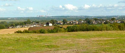
A view of Ferrybridge Power Station from the summit.
-
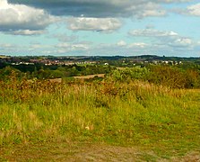
A view of Rothwell from the summit.


.JPG)
.JPG)
Rothwell Country Park has a summit, which boasts 360 degree views of Leeds[2], including a view of Bridgewater Place and Temple Newsam.
See Also
External Links
Notes
- ↑ Heritage Gateway also lists the grid reference SE3521029410, which is more exact than that given by Richardson.
References
- ↑ 1.0 1.1 1.2 The Wildlife Trust (2020). "What's the Damage?". [online]. Available at: <https://www.wildlifetrusts.org/sites/default/files/2020-01/What's%20the%20damage%20-%20Full%20Report%20digital2_0.pdf> [Accessed 7/12/2020]
- ↑ 2.0 2.1 2.2 2.3 2.4 Yorkshire Wildlife Trust. "Rothwell Country Park". [online]. Available at: <https://www.ywt.org.uk/nature-reserves/rothwell-country-park> [Accessed 3/12/2020]
- ↑ West Yorkshire Joint Services, West Yorkshire Archaeology Advisory Service and Historic England, 2017. Leeds Historic Landscape Characterisation Project Final Report. [online] Leeds: WYJS, p.750. Available at: <https://www.wyjs.org.uk/media/69833/leeds-historic-landscape-characterisation-project-report.pdf> [Accessed 17 July 2022].
- ↑ leeds.gov.uk. n.d. Forest of Leeds - Rothwell. [online] Available at: <http://web.archive.org/web/20120220102139/http://www.leeds.gov.uk/fol/fol_46.html> [Accessed 20 July 2022].
- ↑ 5.0 5.1 5.2 5.3 5.4 5.5 5.6 5.7 5.8 5.9 Friends of Rothwell Country Park. "History of the Park". [online]. Available at:<https://sites.google.com/site/friendsofrothwellcountrypark/about-the-park> [Accessed 3/12/2020]
- ↑ Barker, A., Churchill, D. and Crawford, A. (2018) Leeds Parks Survey: Full Report. rep. Leeds: University of Leeds.
- ↑ 7.0 7.1 Richardson, J., 2011. Rothwell Haigh, Rothwell, Leeds, West Yorkshire - Excavation Report. [online] Wakefield: ASWYAS. Available at: https://archaeologydataservice.ac.uk/archiveDS/archiveDownload?t=arch-941-1/dissemination/pdf/archaeol11-92831_1.pdf [Accessed 17 July 2022].
- ↑ 8.0 8.1 Barker, K. (2007) Rothwell Country Park. Leeds: Leeds City Council.
- ↑ 9.0 9.1 Stephen Ward (2020). "Rothwell & District: Pictures & Memories from the Past". Leeds: Stephen Ward Photography and Publishing.
- ↑ 10.0 10.1 BBC Leeds (2009). "From Park to Pit". [online]. Available at:<http://www.bbc.co.uk/leeds/content/articles/2009/03/02/places_rothwell_country_park_feature.shtml> [Accessed on 7/12/20]
- ↑ 11.0 11.1 Anon (n.d.) “Home,” Friends of Rothwell Country Park, [online] Available from: https://sites.google.com/site/friendsofrothwellcountrypark/home (Accessed 3 February 2023).
- ↑ Russell Hotten, BBC News (2021). "HS2 rail extension to Leeds scrapped amid promise to transform rail". [online]. Available at: <https://www.bbc.co.uk/news/business-59334043> [Accessed 23/02/2022]
- ↑ Anon. (2021). Road block on Bullough Lane, Rothwell © Humphrey Bolton CC-BY-SA/2.0, Geograph, Geograph Project Limited, [online]. Available from: https://www.geograph.org.uk/photo/6933942 (Accessed 11 July 2023).
- ↑ Tomkinson, K. (2023) ‘Unanswered Questions Letter’. Available at: <https://democracy.leeds.gov.uk/documents/b29326/Unanswered%20Questions%20Letter%2022nd-Mar-2023%2013.00%20Council.pdf> (Accessed: 3 March 2024).
- ↑ 15.0 15.1 Anon (n.d.) “Maps,” Friends of Rothwell Country Park, [online] Available from: https://sites.google.com/site/friendsofrothwellcountrypark/maps (Accessed 3 February 2023).