No edit summary |
|||
| (11 intermediate revisions by the same user not shown) | |||
| Line 1: | Line 1: | ||
{{Mobile map fix}} |
|||
{{Contribute notice}} |
{{Contribute notice}} |
||
'''Rothwell Country Park''' is a 52 hectares public park, between the north of Rothwell and the Aire and Calder Navigation. |
'''Rothwell Country Park''' is a 52 hectares public park, between the north of Rothwell and the Aire and Calder Navigation. |
||
| Line 24: | Line 25: | ||
| nearby = |
| nearby = |
||
}} |
}} |
||
The park opened on the 24th of June 2000<ref name="frcp" /> and is managed by Leeds City Council, in partnership with the Yorkshire Wildlife Trust and the Friends of Rothwell Country Park.<ref name="ywt" /> |
The park opened on the 24th of June 2000<ref name="frcp" /> and is managed by Leeds City Council, in partnership with the Yorkshire Wildlife Trust and the Friends of Rothwell Country Park.<ref name="ywt" /> The park has approximately 676,817 vistors annually, which makes it the second most visited park in the Leeds South Outer management area, after Springhead Park. Rothwell Country Park is the sole park among Leeds' top 25 most visited parks that does not meet the Leeds Quality Park standard.<ref name="park survey">Barker, A., Churchill, D. and Crawford, A. (2018) Leeds Parks Survey: Full Report. rep. Leeds: University of Leeds.</ref> |
||
The site was excavated in the 1970s and was found to have been possibly inhabited in the Roman era.<ref name="Richardson">Richardson, J., 2011. ''Rothwell Haigh, Rothwell, Leeds, West Yorkshire - Excavation Report''. [online] Wakefield: ASWYAS. Available at: https://archaeologydataservice.ac.uk/archiveDS/archiveDownload?t=arch-941-1/dissemination/pdf/archaeol11-92831_1.pdf [Accessed 17 July 2022].</ref> It was also a hunting ground in the Medieval period and then a colliery in the 19th and 20th Centuries, until it was redeveloped in the mid 1990s.<ref name="frcp">Friends of Rothwell Country Park. "History of the Park". [online]. Available at:<https://sites.google.com/site/friendsofrothwellcountrypark/about-the-park> [Accessed 3/12/2020]</ref> |
The site was excavated in the 1970s and was found to have been possibly inhabited in the Roman era.<ref name="Richardson">Richardson, J., 2011. ''Rothwell Haigh, Rothwell, Leeds, West Yorkshire - Excavation Report''. [online] Wakefield: ASWYAS. Available at: https://archaeologydataservice.ac.uk/archiveDS/archiveDownload?t=arch-941-1/dissemination/pdf/archaeol11-92831_1.pdf [Accessed 17 July 2022].</ref> It was also a hunting ground in the Medieval period and then a colliery in the 19th and 20th Centuries, until it was redeveloped in the mid 1990s.<ref name="frcp">Friends of Rothwell Country Park. "History of the Park". [online]. Available at:<https://sites.google.com/site/friendsofrothwellcountrypark/about-the-park> [Accessed 3/12/2020]</ref> |
||
[[Category:Mining History]] |
[[Category:Mining History]] |
||
| ⚫ | |||
| ⚫ | |||
| ⚫ | |||
| ⚫ | |||
''Main Article: [[Possible Roman Settlement (Rothwell Haigh)]]''<br> |
''Main Article: [[Possible Roman Settlement (Rothwell Haigh)]]''<br> |
||
In the 1970s, the West the West Yorkshire County Archaeology Unit excavated a "ditched rectangular enclosure" at Rothwell Colliery (approx. grid reference SE 352 295 or SE 352 297<ref group="footnotes">[https://www.heritagegateway.org.uk/Gateway/Results_Single.aspx?uid=cf53bdd6-3f9c-4c31-8533-5d8708c9829c&resourceID=19191 Heritage Gateway] also lists the grid reference SE3521029410, which is more exact than that given by Richardson.</ref>) , which is now the site of Rothwell Country Park. |
In the 1970s, the West the West Yorkshire County Archaeology Unit excavated a "ditched rectangular enclosure" at Rothwell Colliery (approx. grid reference SE 352 295 or SE 352 297<ref group="footnotes">[https://www.heritagegateway.org.uk/Gateway/Results_Single.aspx?uid=cf53bdd6-3f9c-4c31-8533-5d8708c9829c&resourceID=19191 Heritage Gateway] also lists the grid reference SE3521029410, which is more exact than that given by Richardson.</ref>) , which is now the site of Rothwell Country Park. |
||
| Line 40: | Line 39: | ||
</div> |
</div> |
||
The excavation showed that there was evidence of human activity on the site from the late 2nd to the early 3rd century. On the site, a Roman well was found, which had been filled with lots of material, including a rare yew bucket, roman pottery, a human skull.<ref name="Richardson" /> |
The excavation showed that there was evidence of human activity on the site from the late 2nd to the early 3rd century. On the site, a Roman well was found, which had been filled with lots of material, including a rare yew bucket, roman pottery, a human skull.<ref name="Richardson" /> |
||
| ⚫ | |||
| ⚫ | |||
In the Middle Ages, Rothwell Country Park would have been part of a large wooded area that nobility used for hunting, such as wild boars. Nobles such as [[John of Gaunt]] would have hunted regularly in this area. <ref name="frcp" /> |
In the Middle Ages, Rothwell Country Park would have been part of a large wooded area that nobility used for hunting, such as wild boars. Nobles such as [[John of Gaunt]] would have hunted regularly in this area. <ref name="frcp" /> |
||
In 1530, the Royal Hunting Park of Rothwell was de-parked and hunting would have subsided, while cattle grazing and eventually coal mining would have increased. <ref name="frcp" /> |
In 1530, the Royal Hunting Park of Rothwell was de-parked and hunting would have subsided, while cattle grazing and eventually coal mining would have increased. <ref name="frcp" /> |
||
| ⚫ | |||
| ⚫ | |||
[[File:Rothwell Colliery - geograph.org.uk - 1565074.jpg|left|thumb|Fanny Pit, as photographed in 1984.|alt=An image of mining buildings at Fanny Pit in 1984.]] |
[[File:Rothwell Colliery - geograph.org.uk - 1565074.jpg|left|thumb|Fanny Pit, as photographed in 1984.|alt=An image of mining buildings at Fanny Pit in 1984.]] |
||
Around 1867, the [[Charlesworth Family|Charlesworth family]] sank a shaft on the site, named Fanny Pit, after the daughter of one of the Charlesworths. Despite millions of gallons of water needing to be pumped out of the shaft every week, the shaft was highly profitable. <ref name="frcp" /> |
Around 1867, the [[Charlesworth Family|Charlesworth family]] sank a shaft on the site, named Fanny Pit, after the daughter of one of the Charlesworths. Despite millions of gallons of water needing to be pumped out of the shaft every week, the shaft was highly profitable. <ref name="frcp" /> |
||
| Line 55: | Line 52: | ||
On the 9th December 1983, the last of the Rothwell Colliery's shafts were closed. They had produced over 75 million tons of coal during the time they were open. <ref name="frcp" /> |
On the 9th December 1983, the last of the Rothwell Colliery's shafts were closed. They had produced over 75 million tons of coal during the time they were open. <ref name="frcp" /> |
||
| ⚫ | |||
| ⚫ | In the mid 1990s, local people, Leeds City Council and Groundwork Leeds, entered a partnership to transform the disused industrial site.<ref name="ywt" /> Construction started in 1997, with the spoil heap lowered, ponds established, trees planted and pathways created.<ref name="LCC report">Barker, K. (2007) Rothwell Country Park. Leeds: Leeds City Council.</ref> Groups and individuals, such as local schoolchildren and local conservationists, contributed to the work. The park was supported by the Millennium Commission, and funding came from the National Lottery's Changing Places programme, Yorkshire Forward, Leeds City Council, the European Commission and the Forestry Commission.<ref name="S Ward Book">Stephen Ward (2020). "Rothwell & District: Pictures & Memories from the Past". Leeds: Stephen Ward Photography and Publishing.</ref> |
||
| ⚫ | |||
| ⚫ | In the mid 1990s, local people, Leeds City Council and Groundwork Leeds, entered a partnership to transform the disused industrial site. |
||
On the 24th June 2000, Rothwell Country Park was opened <ref name="frcp" /> by television presenter and journalist Richard Whiteley. <ref name="BBC">BBC Leeds (2009). "From Park to Pit". [online]. Available at:<http://www.bbc.co.uk/leeds/content/articles/2009/03/02/places_rothwell_country_park_feature.shtml> [Accessed on 7/12/20]</ref> There was a "traditional village fete", which included music and displays by schools, community groups and societies. There were also tours of the park, some by former miners, who explained the mining history of the park, and others explaining how the park was built and what wildlife now inhabited it. There were displays of crafts including willow weaving and stone carving. <ref name="S Ward Book" /> |
On the 24th June 2000, Rothwell Country Park was opened <ref name="frcp" /> by television presenter and journalist Richard Whiteley. <ref name="BBC">BBC Leeds (2009). "From Park to Pit". [online]. Available at:<http://www.bbc.co.uk/leeds/content/articles/2009/03/02/places_rothwell_country_park_feature.shtml> [Accessed on 7/12/20]</ref> There was a "traditional village fete", which included music and displays by schools, community groups and societies. There were also tours of the park, some by former miners, who explained the mining history of the park, and others explaining how the park was built and what wildlife now inhabited it. There were displays of crafts including willow weaving and stone carving. <ref name="S Ward Book" /> |
||
In 2010, after years of underinvestment <ref name="frcp" /> and vandalism, <ref name="BBC" /> the community group, the Friends of Rothwell Country Park, was |
Following the park's opening, it experienced a number of issues, including a lack of revenue, the demise of the Friends of group, travellers' encampments, fly tipping and unauthorised vehicles causing damage. There were also plans for the RSPCA to build a visitor or education centre on the site of Haigh Farm, however this did not come to fruition.<ref name="LCC report" /> In 2010, after years of underinvestment <ref name="frcp" /> and vandalism, <ref name="BBC" /> the community group, the Friends of Rothwell Country Park, was reestablished to maintain the park. |
||
On 9th June 2013, the "Trim Trail" was officially opened, which consisted of a series of outdoor exercise equipment. It was funded by Leeds City Council. Members of the Friends of Rothwell Country Park and representatives of Leeds City Council used the equipment session run by Sarah Crosby of Cross-Fit Personal Training.<ref name=":0">Anon (n.d.) “Home,” ''Friends of Rothwell Country Park'', [online] Available from: <nowiki>https://sites.google.com/site/friendsofrothwellcountrypark/home</nowiki> (Accessed 3 February 2023).</ref> |
On 9th June 2013, the "Trim Trail" was officially opened, which consisted of a series of outdoor exercise equipment. It was funded by Leeds City Council. Members of the Friends of Rothwell Country Park and representatives of Leeds City Council used the equipment session run by Sarah Crosby of Cross-Fit Personal Training.<ref name=":0">Anon (n.d.) “Home,” ''Friends of Rothwell Country Park'', [online] Available from: <nowiki>https://sites.google.com/site/friendsofrothwellcountrypark/home</nowiki> (Accessed 3 February 2023).</ref> |
||
In 2019, the park was designated a Local Wildlife Site. <ref name="wtreport" /> |
In 2019, the park was designated a Local Wildlife Site. <ref name="wtreport" /> |
||
Rothwell Country Park was one of the 13 Wildlife Trust sites within 500m of the proposed HS2 train line. The Wildlife Trust's 2020 report, "What's the Damage?", highlighted how the new proposed HS2 line would go further south into the site, where the highest level of biodiversity is, and that construction would have caused damage and possibly introduced invasive species that had been eradicated from the site back into Rothwell Country Park from its boundaries. <ref name="wtreport" /> The government's announcement that the East Midlands-Leeds high-speed line was to be scrapped<ref>Russell Hotten, BBC News (2021). "HS2 rail extension to Leeds scrapped amid promise to transform rail". [online]. Available at: <https://www.bbc.co.uk/news/business-59334043> [Accessed 23/02/2022]</ref> meant that HS2 would not go through Rothwell Country Park. |
Rothwell Country Park was one of the 13 Wildlife Trust sites within 500m of the proposed HS2 train line. The Wildlife Trust's 2020 report, "What's the Damage?", highlighted how the new proposed HS2 line would go further south into the site, where the highest level of biodiversity is, and that construction would have caused damage and possibly introduced invasive species that had been eradicated from the site back into Rothwell Country Park from its boundaries. <ref name="wtreport" /> The government's announcement that the East Midlands-Leeds high-speed line was to be scrapped<ref>Russell Hotten, BBC News (2021). "HS2 rail extension to Leeds scrapped amid promise to transform rail". [online]. Available at: <https://www.bbc.co.uk/news/business-59334043> [Accessed 23/02/2022]</ref> meant that HS2 would not go through Rothwell Country Park. |
||
==Amenities== |
==Amenities== |
||
===Map=== |
===Map=== |
||
<display_map scrollwheelzoom="off" geojson="Rothwell Country Park"> |
<display_map scrollwheelzoom="off" geojson="Rothwell Country Park"> |
||
| Line 84: | Line 79: | ||
<span style="color:#ff0000">'''Red line'''</span>: Pithead & Sculpture trail. |
<span style="color:#ff0000">'''Red line'''</span>: Pithead & Sculpture trail. |
||
<span style="color:#0000ff ">'''Blue line'''</span>: Pond trail. |
<span style="color:#0000ff ">'''Blue line'''</span>: Pond trail. |
||
<span style="color:# |
<span style="color:#FEC30A">'''Yellow markers'''</span>: Access points. |
||
<span style="color:#008000 ">'''Green markers'''</span>: Points of interest. |
<span style="color:#008000 ">'''Green markers'''</span>: Points of interest. |
||
</center> |
</center> |
||
| ⚫ | |||
[[File:Gate, Bullough Lane - geograph.org.uk - 2036044.jpg|thumb|alt=A road showing a gate and large rocks blocking access.|Access to the park's car park is blocked.|left|200x200px]] |
|||
The access to the park's car park is blocked by a gate and large rocks due to unsocial behaviour so visitors usually park on the residential roads nearby or walk and cycle to the park.<ref name="Geograph Bullough">Anon. (2021). Road block on Bullough Lane, Rothwell © Humphrey Bolton CC-BY-SA/2.0, ''Geograph'', Geograph Project Limited, [online]. Available from: https://www.geograph.org.uk/photo/6933942 (Accessed 11 July 2023).</ref> There were plans to charge for parking at Rothwell Country park in 2023/24, however, as of April 2023, the council no longer plans to do so and thus the car park will remain closed.<ref>Tomkinson, K. (2023) ‘Unanswered Questions Letter’. Available at: <https://democracy.leeds.gov.uk/documents/b29326/Unanswered%20Questions%20Letter%2022nd-Mar-2023%2013.00%20Council.pdf> (Accessed: 3 March 2024).</ref> |
|||
===Trails & Footpaths=== |
===Trails & Footpaths=== |
||
The park has two named footpaths with many more footpaths branching off from them. The Pithead & Sculpture Trail which goes past a series of sculptures and ends at the site of the former stockyard, where abandoned railway lines can still be seen. The Pond Trial goes along many of the numerous ponds in the park.<ref name=":1">Anon (n.d.) “Maps,” ''Friends of Rothwell Country Park'', [online] Available from: <nowiki>https://sites.google.com/site/friendsofrothwellcountrypark/maps</nowiki> (Accessed 3 February 2023).</ref> There is also the Trim Trail, which is on the Pond Trail, which goes past the outdoor exercise equipment that was installed in 2013.<ref name=":0" /> |
The park has two named footpaths with many more footpaths branching off from them. The Pithead & Sculpture Trail which goes past a series of sculptures and ends at the site of the former stockyard, where abandoned railway lines can still be seen. The Pond Trial goes along many of the numerous ponds in the park.<ref name=":1">Anon (n.d.) “Maps,” ''Friends of Rothwell Country Park'', [online] Available from: <nowiki>https://sites.google.com/site/friendsofrothwellcountrypark/maps</nowiki> (Accessed 3 February 2023).</ref> There is also the Trim Trail, which is on the Pond Trail, which goes past the outdoor exercise equipment that was installed in 2013.<ref name=":0" /> |
||
There is access to the Trans Pennine Trail, which follows along side the River Aire.<ref name=":1" /> |
There is access to the Trans Pennine Trail, which follows along side the River Aire.<ref name=":1" /> |
||
| ⚫ | |||
| ⚫ | |||
| ⚫ | |||
| ⚫ | Rothwell Country Park is also home to twenty-one stone and iron sculptures, which mark twenty-one 'Changing Places' sites that had been regenerated. The first sculpture is "Breaking the Mould" by Andrew McKeown. It is of a giant seed breaking out of its mould and is meant to represent "new life and growth emerging from industrial decline". There are also stone figures, willow arches and a sun dial. Another prominent sculpture, which is at the end of the trail, is that of a "dome represents the pit heap and all the way around the sculpture there are people, trees, wildlife, the canal, railway, and the old colliery itself." <ref name="ywt" /> Many of these sculptures are now overgrown by the surrounding trees and plants or have been heavily vandalised.<br /> |
||
| ⚫ | |||
===Summit=== |
|||
| ⚫ | Rothwell Country Park is also home to twenty-one stone and iron sculptures, which mark twenty-one 'Changing Places' sites that had been regenerated. The first sculpture is "Breaking the Mould" by Andrew McKeown. It is of a giant seed breaking out of its mould and is meant to represent "new life and growth emerging from industrial decline". There are also stone figures, willow arches and a sun dial. Another prominent sculpture, which is at the end of the trail, is that of a "dome represents the pit heap and all the way around the sculpture there are people, trees, wildlife, the canal, railway, and the old colliery itself." <ref name="ywt" /> Many of these sculptures are now overgrown by the surrounding trees and plants or have been heavily vandalised. |
||
<gallery mode="packed"> |
|||
File:Rothwell Country Park ^3 - geograph.org.uk - 3959226.jpg|alt=A view of Leeds City Centre from the summit of Rothwell Country Park.|A view of Leeds from the summit. |
|||
| ⚫ | |||
File:Rothwell Country Park ^2 - geograph.org.uk - 3959224.jpg|A view of Temple Newsam from the summit. |
|||
File:View from Rothwell Country Park (3).JPG|A view of Ferrybridge Power Station from the summit. |
|||
File:View from Rothwell Country Park (4).JPG|A view of Rothwell from the summit. |
|||
</gallery> |
|||
Rothwell Country Park has a summit, which boasts 360 degree views of Leeds<ref name="ywt" />, including a view of Bridgewater Place and Temple Newsam. |
Rothwell Country Park has a summit, which boasts 360 degree views of Leeds<ref name="ywt" />, including a view of Bridgewater Place and Temple Newsam. |
||
==See Also== |
==See Also== |
||
*[[Possible Roman settlement (Rothwell Haigh)|Possible Roman settlement - on the site of what is now Rothwell Country Park]] |
*[[Possible Roman settlement (Rothwell Haigh)|Possible Roman settlement - on the site of what is now Rothwell Country Park]] |
||
| ⚫ | |||
| ⚫ | |||
*[https://www.geograph.org.uk/search.php?i=154975896 Photos of the park from Geograph] |
*[https://www.geograph.org.uk/search.php?i=154975896 Photos of the park from Geograph] |
||
==Notes== |
==Notes== |
||
<references group="footnotes" /> |
<references group="footnotes" /> |
||
==References== |
==References== |
||
<references /> |
<references /> |
||
==Your Memories== |
==Your Memories== |
||
<comments /> |
<comments /> |
||
| ⚫ | {{Place nav}}{{PageInfo| seo keywords = rothwell country park, rothwell park, rothwell transpennine way, rothwell river aire, rothwell river calder, rothwell park leeds, rothwell country park leeds, rothwell country park map, rothwell country park postcode, rothwell country park directions, rothwell nature, rothwell nature site, country park leeds, country park yorkshire, rothwell colliery, roman rothwell, rothwell roman settlement, rothwell roman site, rothwell roman history, rothwell medieval hunting ground, rothwell middle ages hunting ground, john o'gaunt, john of gaunt, rothwell colliery, fanny pit, fanny pit rothwell, rothwell mining history, rothwell mining, leeds mining history, mining history yorkshire, millennium park, millennium park leeds, rothwell colliery country park, rothwell colliery country park leeds, rothwell park sculpture, rothwell park summit, rothwell dog park, rothwell nature park, rothwell wildlife site, rothwell country park parking, rothwell country park car park, rothwell country park photos| seo description = Rothwell Country Park is a park between Rothwell and the River Aire. It has a summit, with views of Leeds, and paths along ponds and its mining history.| seo image = 2036080 1848db8e.jpg}}{{#related:Possible Roman settlement (Rothwell Haigh)}}{{#related:Main page}}{{#related:Rothwell Wiki:Places}} |
||
{{PageInfo |
|||
| ⚫ | | seo keywords = rothwell country park, rothwell park, rothwell transpennine way, rothwell river aire, rothwell river calder, rothwell park leeds, rothwell country park leeds, rothwell country park map, rothwell country park postcode, rothwell country park directions, rothwell nature, rothwell nature site, country park leeds, country park yorkshire, rothwell colliery, roman rothwell, rothwell roman settlement, rothwell roman site, rothwell roman history, rothwell medieval hunting ground, rothwell middle ages hunting ground, john o'gaunt, john of gaunt, rothwell colliery, fanny pit, fanny pit rothwell, rothwell mining history, rothwell mining, leeds mining history, mining history yorkshire, millennium park, millennium park leeds, rothwell colliery country park, rothwell colliery country park leeds, rothwell park sculpture, rothwell park summit, rothwell dog park, rothwell nature park, rothwell wildlife site |
||
| seo description = Rothwell Country Park is a large public park, between the north of Rothwell and the Aire and Calder Navigation. The park is a Local Wildlife Site, with a pond trail and a sculpture trail; a summit, which offers a view of Leeds; and connections to the Trans-Pennine Way. |
|||
| seo image = 2036080 1848db8e.jpg |
|||
}} |
|||
Latest revision as of 14:03, 26 March 2024
Rothwell Country Park is a 52 hectares public park, between the north of Rothwell and the Aire and Calder Navigation. The park is a Local Wildlife Site[1], with a pond trail and a sculpture trail; a summit, which offers a view of Leeds; and connections to the Trans-Pennine Way. [2]
The park opened on the 24th of June 2000[5] and is managed by Leeds City Council, in partnership with the Yorkshire Wildlife Trust and the Friends of Rothwell Country Park.[2] The park has approximately 676,817 vistors annually, which makes it the second most visited park in the Leeds South Outer management area, after Springhead Park. Rothwell Country Park is the sole park among Leeds' top 25 most visited parks that does not meet the Leeds Quality Park standard.[6]
The site was excavated in the 1970s and was found to have been possibly inhabited in the Roman era.[7] It was also a hunting ground in the Medieval period and then a colliery in the 19th and 20th Centuries, until it was redeveloped in the mid 1990s.[5]
History of the Site
Roman Britain
Main Article: Possible Roman Settlement (Rothwell Haigh)
In the 1970s, the West the West Yorkshire County Archaeology Unit excavated a "ditched rectangular enclosure" at Rothwell Colliery (approx. grid reference SE 352 295 or SE 352 297[footnotes 1]) , which is now the site of Rothwell Country Park.
The excavation showed that there was evidence of human activity on the site from the late 2nd to the early 3rd century. On the site, a Roman well was found, which had been filled with lots of material, including a rare yew bucket, roman pottery, a human skull.[7]
Middle Ages
In the Middle Ages, Rothwell Country Park would have been part of a large wooded area that nobility used for hunting, such as wild boars. Nobles such as John of Gaunt would have hunted regularly in this area. [5]
In 1530, the Royal Hunting Park of Rothwell was de-parked and hunting would have subsided, while cattle grazing and eventually coal mining would have increased. [5]
Fanny Pit

Around 1867, the Charlesworth family sank a shaft on the site, named Fanny Pit, after the daughter of one of the Charlesworths. Despite millions of gallons of water needing to be pumped out of the shaft every week, the shaft was highly profitable. [5]
In 1921, a second shaft was sunk and then deepened in 1924/25. 160 ponies were kept in underground stables at Fanny Pit in 1922. [5]
In 1947, the pit was nationalised and it began to focus on producing coal quickly for the power stations. This led to the introduction of an underground locomotive system. [5]
On the 9th December 1983, the last of the Rothwell Colliery's shafts were closed. They had produced over 75 million tons of coal during the time they were open. [5]
History of the Park
In the mid 1990s, local people, Leeds City Council and Groundwork Leeds, entered a partnership to transform the disused industrial site.[2] Construction started in 1997, with the spoil heap lowered, ponds established, trees planted and pathways created.[8] Groups and individuals, such as local schoolchildren and local conservationists, contributed to the work. The park was supported by the Millennium Commission, and funding came from the National Lottery's Changing Places programme, Yorkshire Forward, Leeds City Council, the European Commission and the Forestry Commission.[9]
On the 24th June 2000, Rothwell Country Park was opened [5] by television presenter and journalist Richard Whiteley. [10] There was a "traditional village fete", which included music and displays by schools, community groups and societies. There were also tours of the park, some by former miners, who explained the mining history of the park, and others explaining how the park was built and what wildlife now inhabited it. There were displays of crafts including willow weaving and stone carving. [9]
Following the park's opening, it experienced a number of issues, including a lack of revenue, the demise of the Friends of group, travellers' encampments, fly tipping and unauthorised vehicles causing damage. There were also plans for the RSPCA to build a visitor or education centre on the site of Haigh Farm, however this did not come to fruition.[8] In 2010, after years of underinvestment [5] and vandalism, [10] the community group, the Friends of Rothwell Country Park, was reestablished to maintain the park.
On 9th June 2013, the "Trim Trail" was officially opened, which consisted of a series of outdoor exercise equipment. It was funded by Leeds City Council. Members of the Friends of Rothwell Country Park and representatives of Leeds City Council used the equipment session run by Sarah Crosby of Cross-Fit Personal Training.[11]
In 2019, the park was designated a Local Wildlife Site. [1]
Rothwell Country Park was one of the 13 Wildlife Trust sites within 500m of the proposed HS2 train line. The Wildlife Trust's 2020 report, "What's the Damage?", highlighted how the new proposed HS2 line would go further south into the site, where the highest level of biodiversity is, and that construction would have caused damage and possibly introduced invasive species that had been eradicated from the site back into Rothwell Country Park from its boundaries. [1] The government's announcement that the East Midlands-Leeds high-speed line was to be scrapped[12] meant that HS2 would not go through Rothwell Country Park.
Amenities
Map
Red line: Pithead & Sculpture trail. Blue line: Pond trail. Yellow markers: Access points. Green markers: Points of interest.
Parking

The access to the park's car park is blocked by a gate and large rocks due to unsocial behaviour so visitors usually park on the residential roads nearby or walk and cycle to the park.[13] There were plans to charge for parking at Rothwell Country park in 2023/24, however, as of April 2023, the council no longer plans to do so and thus the car park will remain closed.[14]
Trails & Footpaths
The park has two named footpaths with many more footpaths branching off from them. The Pithead & Sculpture Trail which goes past a series of sculptures and ends at the site of the former stockyard, where abandoned railway lines can still be seen. The Pond Trial goes along many of the numerous ponds in the park.[15] There is also the Trim Trail, which is on the Pond Trail, which goes past the outdoor exercise equipment that was installed in 2013.[11]
There is access to the Trans Pennine Trail, which follows along side the River Aire.[15]
Sculptures

Rothwell Country Park is also home to twenty-one stone and iron sculptures, which mark twenty-one 'Changing Places' sites that had been regenerated. The first sculpture is "Breaking the Mould" by Andrew McKeown. It is of a giant seed breaking out of its mould and is meant to represent "new life and growth emerging from industrial decline". There are also stone figures, willow arches and a sun dial. Another prominent sculpture, which is at the end of the trail, is that of a "dome represents the pit heap and all the way around the sculpture there are people, trees, wildlife, the canal, railway, and the old colliery itself." [2] Many of these sculptures are now overgrown by the surrounding trees and plants or have been heavily vandalised.
Summit
-

A view of Leeds from the summit.
-

A view of Temple Newsam from the summit.
-
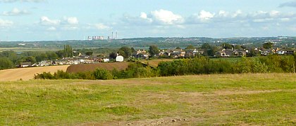
A view of Ferrybridge Power Station from the summit.
-
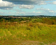
A view of Rothwell from the summit.


.JPG)
.JPG)
Rothwell Country Park has a summit, which boasts 360 degree views of Leeds[2], including a view of Bridgewater Place and Temple Newsam.
See Also
External Links
Notes
- ↑ Heritage Gateway also lists the grid reference SE3521029410, which is more exact than that given by Richardson.
References
- ↑ 1.0 1.1 1.2 The Wildlife Trust (2020). "What's the Damage?". [online]. Available at: <https://www.wildlifetrusts.org/sites/default/files/2020-01/What's%20the%20damage%20-%20Full%20Report%20digital2_0.pdf> [Accessed 7/12/2020]
- ↑ 2.0 2.1 2.2 2.3 2.4 Yorkshire Wildlife Trust. "Rothwell Country Park". [online]. Available at: <https://www.ywt.org.uk/nature-reserves/rothwell-country-park> [Accessed 3/12/2020]
- ↑ West Yorkshire Joint Services, West Yorkshire Archaeology Advisory Service and Historic England, 2017. Leeds Historic Landscape Characterisation Project Final Report. [online] Leeds: WYJS, p.750. Available at: <https://www.wyjs.org.uk/media/69833/leeds-historic-landscape-characterisation-project-report.pdf> [Accessed 17 July 2022].
- ↑ leeds.gov.uk. n.d. Forest of Leeds - Rothwell. [online] Available at: <http://web.archive.org/web/20120220102139/http://www.leeds.gov.uk/fol/fol_46.html> [Accessed 20 July 2022].
- ↑ 5.0 5.1 5.2 5.3 5.4 5.5 5.6 5.7 5.8 5.9 Friends of Rothwell Country Park. "History of the Park". [online]. Available at:<https://sites.google.com/site/friendsofrothwellcountrypark/about-the-park> [Accessed 3/12/2020]
- ↑ Barker, A., Churchill, D. and Crawford, A. (2018) Leeds Parks Survey: Full Report. rep. Leeds: University of Leeds.
- ↑ 7.0 7.1 Richardson, J., 2011. Rothwell Haigh, Rothwell, Leeds, West Yorkshire - Excavation Report. [online] Wakefield: ASWYAS. Available at: https://archaeologydataservice.ac.uk/archiveDS/archiveDownload?t=arch-941-1/dissemination/pdf/archaeol11-92831_1.pdf [Accessed 17 July 2022].
- ↑ 8.0 8.1 Barker, K. (2007) Rothwell Country Park. Leeds: Leeds City Council.
- ↑ 9.0 9.1 Stephen Ward (2020). "Rothwell & District: Pictures & Memories from the Past". Leeds: Stephen Ward Photography and Publishing.
- ↑ 10.0 10.1 BBC Leeds (2009). "From Park to Pit". [online]. Available at:<http://www.bbc.co.uk/leeds/content/articles/2009/03/02/places_rothwell_country_park_feature.shtml> [Accessed on 7/12/20]
- ↑ 11.0 11.1 Anon (n.d.) “Home,” Friends of Rothwell Country Park, [online] Available from: https://sites.google.com/site/friendsofrothwellcountrypark/home (Accessed 3 February 2023).
- ↑ Russell Hotten, BBC News (2021). "HS2 rail extension to Leeds scrapped amid promise to transform rail". [online]. Available at: <https://www.bbc.co.uk/news/business-59334043> [Accessed 23/02/2022]
- ↑ Anon. (2021). Road block on Bullough Lane, Rothwell © Humphrey Bolton CC-BY-SA/2.0, Geograph, Geograph Project Limited, [online]. Available from: https://www.geograph.org.uk/photo/6933942 (Accessed 11 July 2023).
- ↑ Tomkinson, K. (2023) ‘Unanswered Questions Letter’. Available at: <https://democracy.leeds.gov.uk/documents/b29326/Unanswered%20Questions%20Letter%2022nd-Mar-2023%2013.00%20Council.pdf> (Accessed: 3 March 2024).
- ↑ 15.0 15.1 Anon (n.d.) “Maps,” Friends of Rothwell Country Park, [online] Available from: https://sites.google.com/site/friendsofrothwellcountrypark/maps (Accessed 3 February 2023).